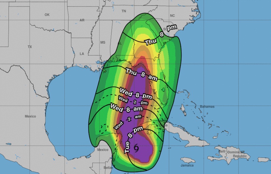
BERKELEY COUNTY, S.C. – A tropical storm warning is in effect for Berkeley County until further notice. As Hurricane Helene prepares to make landfall in Florida before pushing north, Berkeley County Emergency Management continues to monitor the potential for high winds and increased rainfall with isolated flooding.
Gov. Henry McMaster declared a state of emergency Wednesday in preparation for the potential effects of Hurricane Helene, and asks South Carolinians to monitor local forecasts and begin taking proper precautions.
“Although South Carolina will likely avoid the brunt of Hurricane Helene’s impacts, the storm is still expected to bring dangerous flooding, high winds, and isolated tornadoes to many parts of the state,” said McMaster. “This State of Emergency ensures that Team South Carolina has the necessary resources in place to respond to these potential impacts. South Carolinians in potentially affected areas should start to take precautions now and monitor local weather forecasts over the next several days.”
According to forecasters with the National Hurricane Center, Hurricane Helene is currently situated in the Gulf of Mexico and is anticipated to intensify before making landfall along the coast of Florida as a hurricane on Thursday.
The storm is then expected to impact South Carolina and other southeastern states with strong winds, significant rainfall, flash flooding, and an enhanced risk of isolated tornadoes.
The risk for tornadoes will increase during the day Thursday and peak Thursday night into early Friday morning.
Tropical storm force winds, mainly in frequent gusts of 40 to 60 mph, are forecast to increase across Southeast Georgia and the adjacent Atlantic Georgia waters Thursday evening, then expand into southeast South Carolina and the adjacent coastal waters Thursday night.
Wind speeds should peak late Thursday night as the center of Helene moves across central Georgia.
Rain bands with Helene will begin to impact Southeast Georgia before daybreak Thursday, then increase in both coverage and intensity across the remainder of Southeast South Carolina and Southeast Georgia Thursday into Thursday night.
The rain should quickly end Friday morning as Helene moves into the southern Appalachians. Rainfall amounts will average 1.5 to 3 inches with isolated higher amounts possible, especially west of the Interstate 95 corridor. Minor flooding of low-lying and poor drainage areas is likely in some areas with isolated flash flooding possible.
Storm surge inundation of 1 to 3 ft is possible along the South Carolina Lowcountry. In addition, high surf, strong and dangerous rip currents and beach erosion are likely at the beaches.


Recent Comments